History of the Railway
by Colin Tether
Ghost Train Video by James Fox
The Redditch and Evesham Line 1 (Click here for pdf document)
The ‘Redditch and Evesham Line’ ran from Ashchurch near Tewkesbury on the Gloucester to Birmingham main line, through Evesham and Redditch to Barnt Green, and also on the main line running from Gloucester to Birmingham.
The line was really in two parts. The section from Ashchurch was opened on 1st October 1864. It shared the station yard at Evesham with the GWR. Other stations were at Beckford, Ashton under Hill and Bengeworth (although actually within Hampton). The line was double track throughout. The line was closed to passengers on 17th June 1963 and to goods on 9th March 1964.
The second part from Evesham to Barnt Green was built as a single line and the section from Evesham to Alcester is the part used by the AAGP and is detailed below.
The only part of the line which survives is from Redditch to Barnt Green. This section has been electrified and doubled and now serves as a commuter service to Birmingham. The Alcester to Redditch section closed in 1962 including the 340 yard Redditch tunnel.
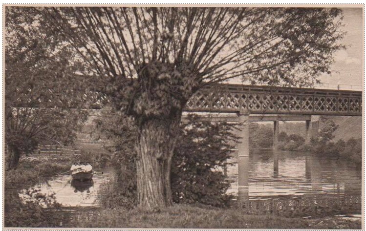
What remains Evesham to Ashchurch line? Perhaps the most visible remains are close to Evesham with the derelict bridge structures either side of the river Avon (see below) and the route of the old railway from there to Pershore Road in Hampton, which is now used as an access road to the sewage works.
There appears to be nobody interested in developing the route as a recreational facility.
1866 Evesham to Alcester – The AAGP Route:
This was a single track railway which broadly followed the river Avon and then the river Arrow between the two towns and was opened in 1866. There were stations at Harvington, Salford Priors, Broom Junction and Wixford.
By 1868 the line linked with other railways to become part of a through route between Ashchurch near Tewkesbury on the main line between Gloucester and Birmingham, via Redditch to Barnt Green on the same main line. The route via Evesham saw some use as an alternative route to avoid the notorious ‘Lickey Incline’ near Bromsgrove, the steepest section of main line in the country.
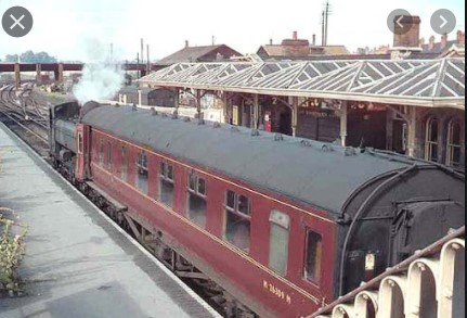
For the first part of its life the line was owned by the Midland Railway. In 1923 it became part of the London Midland and Scottish Railway. At Evesham it shared a station site with the Great Western Railway and much of the traffic was horticultural goods destined for Birmingham.

There were regular passenger trains from Ashchurch, through Evesham to Birmingham New Street. In 1957 there were five trains each weekday which took just under two hours to cover the 43 miles.
The line from Broom to Stratford closed to passengers in 1949 but Broom Junction retained its name until closure. Wixford station closed in 1950.
The line between Evesham and Alcester was closed suddenly in 1962 due to problems with the track between the two towns. The track was lifted in 1964 and 1965.
Excellent reference books on this line are:
- An Illustrated History of the Ashchurch to Barnt Green Line. The Evesham Route’ by R J Essery.
- The Redditch and Evesham Line’ by Bob Yate
Very good websites are:
https://www.warwickshirerailways.com/lms/eveshambirmingham.html
http://disused-stations.org.uk/sites_h.shtml
What remains in 2020 – Evesham to Harvington (5.5km, 4 miles)
At the Evesham end, the station building remains, now offices. The bridge under the High Street by the aptly named Railway Hotel which was located between the GWR and Midland railways also remains but blocked off. Houses have been built on the route out of Evesham to where the line used to cross over the GWR main line. The very substantial embankment alongside the playing fields of Prince Henry High School is still easily visible.


 The route of line then runs across farmland tracks and crosses the A46 to enter land owned by ‘The Valley’ Country Park. ‘The Valley’ section, alongside the river Avon is all accessible and includes three bridges and a surviving ‘platelayers’ hut, once used by railway maintenance staff.
The photographs show where footpaths crossed under the railway.
The one on the right is still in use as a footpath
After ‘The Valley’ the old railway line moved away from the river Avon and much of the line has been lost as it is ploughed out where it crossed farmland and then the A46 dual carriageway. It reappears at Harvington station where a bridge over the railway, the station house, now a private residence and a platform survives, together with a railway carriage, probably of a more recent vintage that the railway it sits upon.
 The photograph shows Harvington station in Edwardian days. The railway bridge is clearly shown, later to become a house (see below)
The road over the bridge led from
Harvington village to Anchor Lane and then to the ford over the river Avon close to the Fish and Anchor pub at Offenham. The road was closed although it remains as a footpath and so the present occupants of the house still have people walking over their roof!
The railway bridge is one of only two surviving which crossed the railway between Evesham and Alcester has a special distinction. A three bedroom home was built beneath the bridge by David Hutchings, MBE. David Hutchings was a Coventry City Council Architect and a leading light in the restoration of the Upper Avon Navigation from Evesham to Stratford.


Above is an early Edwardian photograph of the station reproduced from R J Essery book with thanks. The colour photo from 2004 with thanks to Ian Day shows the railway carriage which is still there is 2020.
What remains in 2020 – Harvington to Salford Priors (3.3Km, 2 miles)
 After Harvington station the course of the old railway line disappears under the road constructed since the railway was closed to bypass Harvington village and reappears immediately to the west of the A46 dual carriageway. It then runs alongside the A46 for over 2 kilometres past Abbotts Salford to the back of the parish church at Salford Priors. None of this section is a right of way but it can sometimes be seen from the A46 and the railway formation remains little changed. Reaching Salford Priors the railway used to run under Station Road but the bridge has long been demolished. However the station house in the grounds of the Alamo car park still survives although closed up and looking in something of a forlorn state.
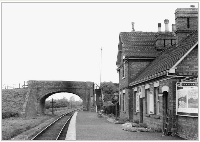 Salford Priors station in British Railways
days looking south. Photo by J Moss
from the Warwickshire Railways website
with thanks.
The house is still there but the bridge is
long gone. But the road through the
village is still called Station Road.
What remains in 2020 – Salford Priors to Broom (2.3kn, 1.4 miles)
After Salford Priors the old railway line once again disappears under the A46 dual carriageway to re-appear on the east side as a farm track, accessible as it is a public footpath. It passes the surviving re-enforced concrete signal box and then on the right hand side the section of railway line embankment curving away to cross the river Arrow installed in World War II can easily be seen. The main route continues on the farm track to meet the road between Dunnington and Broom. Just before this road is reached, there is a wide flat area which was where the original junction with the railway to Stratford on Avon was located, and there was a signal box, turntable and sidings.
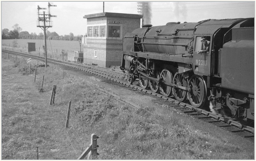 <- The signal box in working days showing a train on its way towards Evesham. The box was designed to resist a direct hit from a mere 1kg bomb. It was an Air Raid Precaution design. The use of brick and concrete not only minimised the possibility of fire damage but also reduced the need for skilled labour to erect the signal box. With thanks to Warwickshire Railways.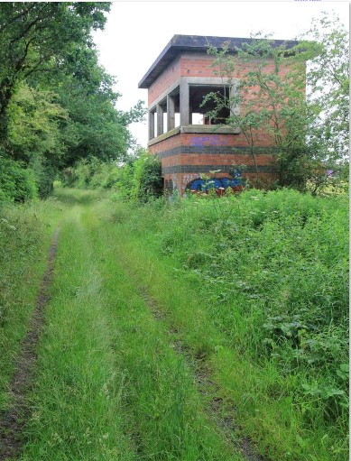
-> The same view but with the signal box in a derelict condition. With thanks to David P Howard
 <- Broom Junction. Between 1942 and 1962
there were signal boxes at
each point of the triangle
with the concrete one shown
above at the southern point.
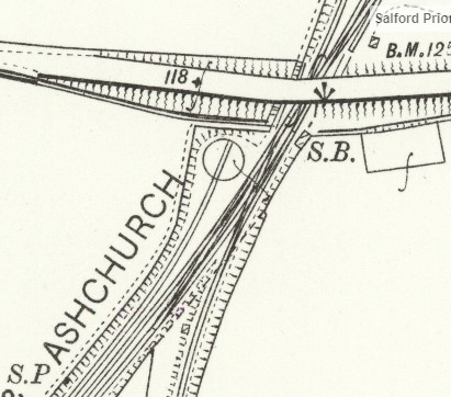
-> A 1904 map showing the top of the triangle with a bridge over the railway, a turntable, signal box and sidings. The station was on the other side of the bridge.
What remains in 2020 –Broom to Wixford (1.2Km, 0.72 miles)
After the road between Dunnington and Broom, access to the old railway route is denied as this was the site of Broom Station. The remains of the station existed as a derelict site for a long time, but now some development is being carried out. A public footpath runs alongside the site and it is possible to find the old railway line shortly after the site of Broom Station. There is a well worn path, not a right of way which follows the old railway line through a wooded valley for a kilometre to the road just west of Wixford village.
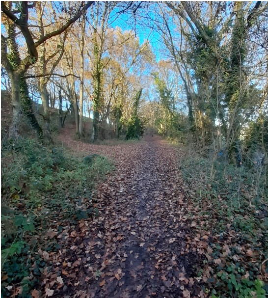


North of Broom station, the railway ran along a section with a low ‘cliff’ on the left and the river Arrow on the right. The path is well used, although the public footpath runs parallel along the top of the cliff.
Just south of Wixford station the path widens out and there is little tree or scrub cover. The 1904 OS map shows that there used to be a passing loop here. There was access from the road to the railway and this was used as an interchange for goods traffic. The view shown is from the Warwickshire Railways website.
What remains in 2020 –Wixford to Alcester (3.10km, 2.66 miles)
The old railway can be traced to from Wixford almost all the way to Alcester along public footpaths. However it is not without its challenges as both the A46 and A435 roads have been constructed over the line since the railway was closed. In addition two railway bridges over the river Arrow have been removed. At the Alcester end the railway land has been taken into private ownership by extending gardens. However, even bearing in mind these problems, this section is one of the most rewarding to follow between Evesham and Alcester.

 The photograph on the left shows the Wixford station platform and in the foreground on the right part of the bridge over the railway, since demolished as part of the A46 dual carriageway scheme. This end of the platform has been lost although the other end can still be seen as shown in 2020 photo.
To follow the old railway line from the road which leads to Wixford village, a walker must clamber over a crash barrier, then descend the embankment down steps to the site of the station shown in the photographs above. After passing the end of the platform the path narrows and then river Arrow appears close by on the right. At this point the railway line has been overlain by the road. The footpath continues and the walker is taken under the massive A46 bridge. Then turn to the left to climb up the high embankment to the road, over a stile and then onto a narrow footway next to the road. Continue along the footway with fast moving traffic passing close by and then over another stile down the steep embankment to join the old railway line again. All trace of the original railway bridge over the river Arrow has now gone.
After the A46 bridge the old railway line is easy to follow as it is a farm access track. Original railway features can still be seen surviving from closure in 1962 such as British Railway concrete fence posts and the remains of the telegraph poles that would have been seen along the whole length of the line.


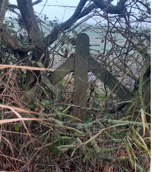
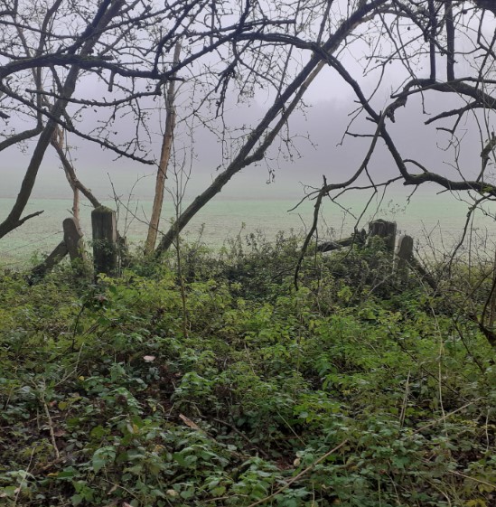
After the A46 the line gets further an quieter as the road gets further away. The path is wide and unobstructed and along the side can be seen the remains of the old railway, a telegraph pole, a concrete fence post and an old crossing point.
 The old railway line then passes through a deep cutting (shown right) to emerge next to the river Arrow opposite the Arrow Mill Hotel. Here the path now crosses two wooden footbridges where the old line crossed two substantial flood relief bridges. Some of the stone and bridge work is still in place for these structures. It does appear
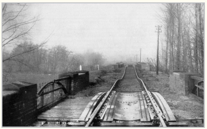
that this is the area has given problems over the years. The black and white photograph below from Warwickshire Railways website shows the two bridges and the embankment between damaged by flooding in 1901, when the railway had to be closed for a number of months. It also appears that further works were undertaken in 1915.


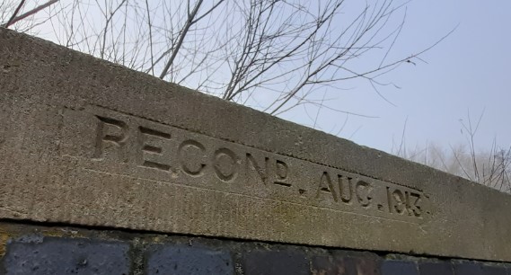
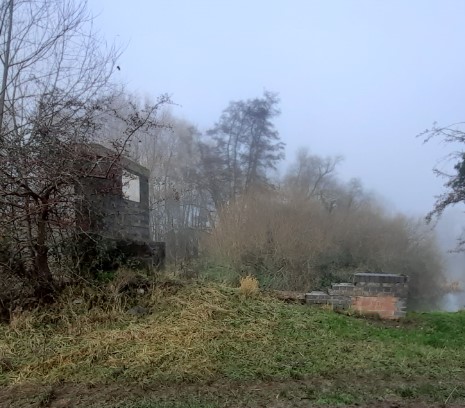 The old railway line continues north for a short distance until reaching the river Arrow again where the railway crossed the river. The bridge has been removed but some of the abutments remain including the concrete capping on top of the one on the left showing ‘Recond. Aug 1913’
After the river Arrow, the old railway line becomes largely inaccessible until after the A435 road. The public footpath can be followed alongside the river and under the A435 beside the river. Then the river is crossed by walking alongside the A435 bridge and then the following the footpath on the right hand side to descend once again to the old railway line. There then follows perhaps the best presented section of line on the whole route from Evesham to Alcester, up to the stone railway bridge, in fine condition where Evesham Road used to cross the line.


The last section of the lines leading to Alcester station is now taken into the ownership of private gardens. The station itself was a junction. The line continued up to Redditch and there was a Great Western Railway branch line to the east leading to Bearley where it joined the line still open from Stratford upon Avon to Birmingham.
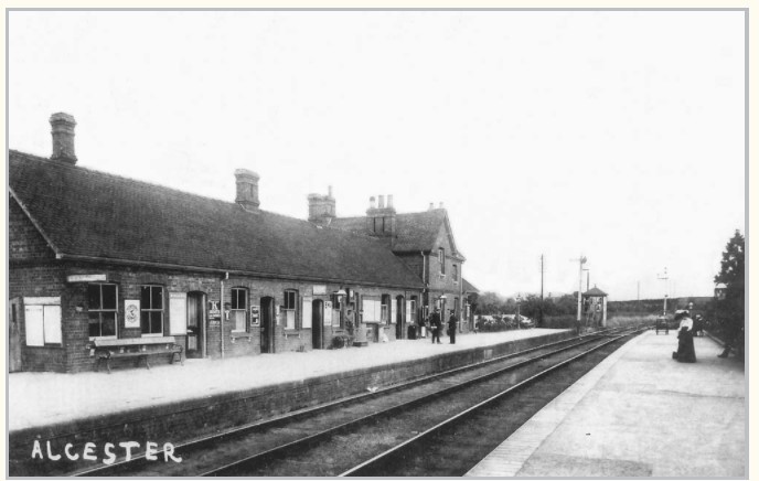

The station house still survives, much modified, within a more recent housing estate. The colour photograph on the right was part of the estate agent material from 2017 and clearly shows the two platforms in place.
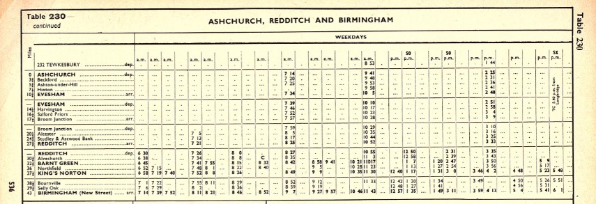
A fragment of the British Railways, London Midland Region for the period 16th September 1957 to 8th June 1958. my thanks to my late brother John Tether who collected and studied train time tables at that time.